A trail along the Yukon River — from one end of the city to the other


References
Yukon River corridor plan, 1999. A very useful look at the waterfront and a good starting point for looking at a creating a Yukon River Trail, identifying and then connecting the existing pieces.
Environmental and Hydrologic Overview of the Yukon River Basin, Alaska and Canada is a good technical description of the river.

November 18, 2019. 17-mile hike to unite San Fancisco A motley alliance decided a single trail could unite this divided city. SF Crosstown Trail neat.
May 25, 2016. Here's a page of the whole Yukon River Trail idea.
May 15, 2016. Draft of a new loop walking trail: Lines of Communication, 5.1 km, and a draft of a Yukon River West, south end trail.
April 24, 2016. Parks' Yukon has an application to upgrade the Wolf Creek Trail under the Canada 150 celebrations. This made me look more closely at the ~15 km walk from the VRC downtown out to the Wolf Creek Camprground and how easy making this route could be.
Sept 7, 2014. Aziza Chaouni: How I brought a river, and my city, back to life Interesting to have architects become activists to work to their vision.
February 21, 2014. Coasting along to nowhere. It seems that trying to bring awareness of paths by water is not easy, even in England. We hiked the coastal trail on the Isle of Wight, and also the Isle of Man. Great experiences.
January 13, 2014. See also Walking Whistle Bend; A walker's look at downtown–Marwell and Range Road trails
Why living near water is good for your mind: Putting down roots near a shoreline could help combat depression.
 Whitehorse needs more focus along the river. A Yukon River Corridor walking trail (draft shown to right) would be a real coup for our city. Some of the land that the trail would pass through is KDFN land (purple) and obviously KDFN would be a major player in such a trail. Is it too late to think this riverside walking trail could happen for Whitehorse?
Here's another map variation on the idea. Purple is more or less existing or planned. Whistle Bend is a bit unknown; some paved trails are in place, but no links to the cliffs trail are highlighted. The cyan are the ends of the trail at the city limits. I haven't walked these so have no idea if any trail exists. At the south end of the cyan I've started the trail at the Yukon River bridge and followed a lovely trail part way.
 Let's look ahead a few years. If we want a strong walking culture, the city should also look ahead for growth of walking trails — presently it looks ahead for roads, for development, for motorized trails, for mountain bike trails. Walking needs its share of the city's attention.
The important thing is to keep this walking trail away from roads and as much along the river or viewscapes (like up on escarpments) as possible. There are certainly parts of the trail that are fragile, but walkers like views and leave a small environmental footprint.
Tthe city is looking at development on the east side of the river. So also should we look at a trail along the river on that side.
Edmonton as an example
Edmonton is built along a river and has managed to preserve a vast swatch as greenbelt alongside the river:
"Edmonton's river valley constitutes the longest stretch of connected urban parkland in North America, and Edmonton has the highest per capita area of parkland of any Canadian city; the river valley is 22 times larger than New York City's Central Park.
The public river valley parks provide a unique urban escape area, with park styles ranging from fully serviced urban parks to campsite-like facilities with few amenities. This main "Ribbon of Green" is supplemented by numerous neighbourhood parks located throughout the city, to give a total of 111 km2 of parkland. Within the 7,400 ha, 25 km-long river valley park system, there are 11 lakes, 14 ravines, and 22 major parks, and most of the city has accessible bike and walking trail connections. These trails are also part of the 235 km Waskahegan walking trail. The City of Edmonton has named five parks in its River Valley Parks System in honour of each of "The Famous Five".
"Several golf courses, both public and private, are also located in the river valley; the long summer daylight hours of this northern city provide for extended play from early morning well into the evening. Golf courses and the park system become a winter recreation area during this season, and cross-country skiing and skating are popular during the long winter. Four downhill ski slopes are located in the river valley as well, two within the city and two immediately outside." Wikipedia
 City limits at Takhini River bridge to Whistle Bend

I need to hike this area more.
Whistle Bend to downtown
 This section of a Yukon River Trail has lots of possibilities. Whistle Bend is projected to house between 8,500 and 10,000 people. Read more on the Whistle Bend project. I need to try harder to get answers to questions I've asked Planning.
Then there's the Yukon River confluence with McIntyre Creek. There's an ideal spot to put a bridge. Also, safe road crossings need to allow the obvious trail connections across to Middle McIntyre Creek.
There's two trails along part of this, and upper and lower along the river. The lower one is interesting and will be attractive for interpretation possibilities. It also allows bypassing some of the existing development along the upper escarpment edge. The upper trail goes along through a mix of old and new small subdivisions. A trail route through some of the industrial properties and subdivisions is badly needed before future development blocks all trail hopes. There's a large Kwanlin Dun land block (C-15B), Mountainview Place, Northland Trailer Park, Takhini Bluffs, Kwanlin Dun subdivision (C-194B) and Takhini Trailer Park. Not sure the total population but will try to find out. See the Range Road North page.
Finally, the last piece before downtown's waterfront Trail is the Marwell area. The trail then falls into the Marwell wetlands(name?), part of Kwanlin Dun's C-194B land block. The Marwell area offers some interesting possibilities here. Presently there is no trail connection through Marwell.
Downtown to Miles Canyon
 The waterfront Trail and the Millennium Trail make up a big part of this section. First, look at Building a pedestrian bridge to network of hospital trails from near Main Street to the hospital.
Next, from the Millennium Bridge to the footbridge at Miles Canyon there's a trail on both sides of the river. I think that the trail at the end of Schwatka Lake may be routed over the road instead of the current trail along the steep slope. The city is looking at this area as part of a Schwatka Lake planning study.
 Miles Canyon to city limits

The trails along the east side of the river go almost to the city limits. On the west side, it looks like a few sections of trails to map:
- Miles Canyon to the American Laundry Road has a number of trails, shown on YukonBiking.ca
- American Laundry to Fox Farm Road, crossing Basalt and Nacrae creeks
- Fox Farm Road to behind the homes in Fox Haven
- then connectinting to the many trails behind Pineridge
- Wolf Creek Trail
- Beyond Wold Creek and crossing Cowley Creek
One day, I suspect there'll be a nice foot trail all the way along to the Yukon River Bridge, only about 15 km past the city limits. Note that much of the land along the river here is KDFN. I wonder what the cultural resources folk and the youth education folk could do here.
Things to think about
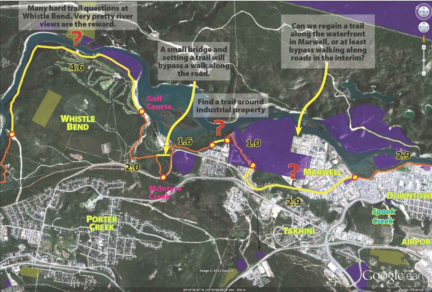
First, here's a blowup of the above maps with notes on places needing to be looked at.
Alongside the river needs special zoning. A good example of this is at Whistle Bend. At Whistle Bend, the PE-zoned land is not always the best place for a trail. So there should be an additional PW-, PG- designated band for a corridor trail. The zoning presently proposed has a lot of land designated as FP. FP does allow trail development, but this puts off the choice of having a Yukon River Corridor Trail onto future city planners. In short, it makes it needlessly complicated in coming years to create a corridor trail if the zoning doesn't specifically designate it.
Additionally, if the city finds itself on the opposite side of the river needing land for development, then the river corridor trail on the other side of the river should also have already been protected. Perhaps then we won't find ourselves in situations such as Marwell where industrial contamination, and storage of old equipment takes priority over recreational walking. See Marwell area for some discussion on this part of the River. Also Spook Creek is another piece in having a great riverfront trail.