promoting walks and walking in Whitehorse, the Yukon's wilderness city |
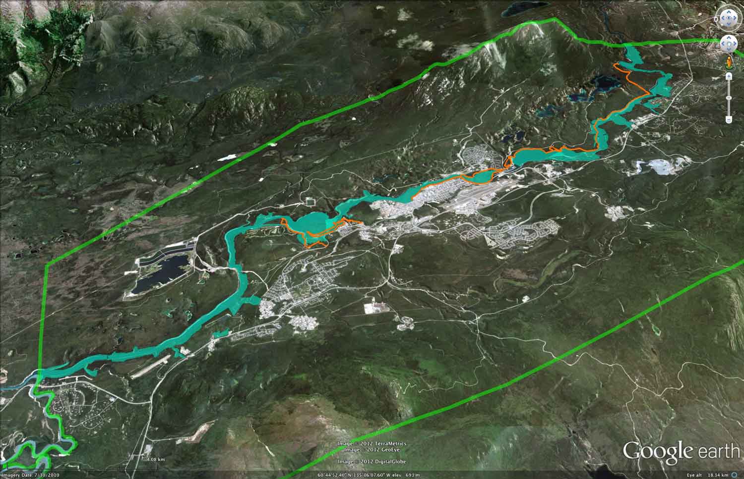
January 22, 2013. The Blind Hiker, How one man used technology to conquer the 2,000-mile Appalachian Trail. My idea of a blind trail at the hospital seems pretty tame compared to this! Working on the two neighbourhood trail task force surveys prompted me to update a map I created a number of years ago. The Google Earth map here shows a set of 'We're proud of our community' city center trail loops.
5 tips for keeping warm during a Canadian winter "You don't want to look like you're dressed to go hiking in the Yukon, while in the middle of the city." Great line, and what are we supposed to do in Whitehorse? January 21, 2013. Finally, I've posted my two neighbourhood trail task force responses: first for the Yukon River East Side and second the Above-the-Airport. And, after 9 months, I've made a second Artsnet post. January 20, 2013. I updated the Logan Arkell Wetlands and walking opportunities page and introduced my idea for a Get to the Ridge route. I hope to post my above-the-airport survey response shortly. January 19, 2013. With all the trail task force material I look at, I often think about walkers and how far they walk and their needs. How far will we walk to go somewhere? It depends discusses this and while about down south pedestrians, It's interesting to think about trail walkability and why we choose one trail over another. I'm working still to get my understanding of trails and parks and maintenance and stewardship together. I've revamped the Walking improvements needed page. I'll tighten it more yet. I don't want the focus of the site to be prodding the city to incorporate a walking vision. It's only a small part of what I want the site to be. January 18, 2013. I've started to look at the trail task force recommendations and surveys. I've made a preliminary map of the Yukon River East Side proposals. January 16, 2013. America is a walking disaster. Now think about crossing the Alaska Highway at the ends of the airport. Jan 14, 2013. Today I've added made a favourite walks page for the entries from YCS's Take a Walk! writing competition. If you've a walk you want to share, send in your story. Note that the above-the-airport's Proposed Trail Network Overview Map refers to proposed Paddy's Pond/Ice Lake park boundaries. Is there a plan afoot to remove Park status for this Park? The OCP says "These park areas are intended to be preserved for all future residents of Whitehorse. Prioritization of Trail Plan implementation measures shall be considered for these Park areas." Trail Plan comments will be in the Above-the-airport, City Center and Yukon River East Side section of trail work dealing with land based items, and in Consultation with the City in process of task force items. Submission to city sent. Jan 13, 2013. As a walker, I'm trying to put a submission in towards the the current city processes this week: the 2013-16 Budget public input and the Corporate priorities for the 2012-15 Strategic Plan cycle. Jan 11, 2013. As one person talking to the city, I can't easily change things: (on a number of occasions the city has told me "we don't hear this from others", "you're the only one saying this...", "become part of some organization...". It's made me look more carefully at the process of consultation with the city. And with the two trail Task forces, there's an obvious parallel story, consultation with Parks and trails. I'll address these soon with a couple of links on the Walking improvements needed page. I will also start to look more closely at the two trail task force surveys which are all about the consultation process. But it's also has me trying to ensure the website has a strong focus on creating a walking culture, and also a strong focus on examining the city's approach to working on trails and greenspaces. I live in Hillcrest and will use our greenspace as impetus. December 20, 2012. Yeah, now I have a logo! How official is that. Thanks Pat. December 12, 2012. Lots for walkers to look at. Porter Creek D open house tonight, and Riverdale's trail task material is starting to be displayed. I've sent a note to Parks asking about a version of the maps that can be used to distinguish the trail categories. For instance there's 5 purply-red trails. Impossible to get an idea of what the task force was thinking. Peace and quiet: What is disappointing is that there's no recognition of having non-motorized areas. The ATV by-law task force voted 100% in favour of every area in the city having a quiet haven for walking (see Walking ideas: peace and quiet), where motorized recreation vehicles are excluded. This is also a problem with proposing that snowmobilers get to have an official trail through Paddy's Pond. It means that as a community we have a more difficult time having an area quiet space. This issue isn't mentioned in the above-the-airport survey, nor the Riverdale survey. Is it possible the city wants to have no areas of the city allowed to be motor vehicles-free? If so, then they should state this and explain why they don't want us to have this. If not, then the surveys should ask what people think. Note that Riverdale isn't asked their opinion of the ball diamond stairs. They are a neighbourhood who would greatly benefit from this new trail connection. If Whitehorse is serious about wanting to increase the health of its citizens by encouraging them to walk, then this is a big oversight. December 10, 2012. The two task forces are done and the public gets little time for feedback — January 4, 2013 specifically. The results and a survey can be found on the Parks and trails homepage. It's very important that walkers fill out this survey. I will try to get an assessment of the results over the next days. If we are to extend our walking trails, then we need to learn more about the Ball Diamond stairs (see Walking ideas: Ball diamond stairs). They also propose granting the snowmobile club official permanent status in using Paddy's Pond. There's no mention of the unsafe conditions this creates on the Toboggan Trail, that this will mean future improvements to Paddy's Pond, such as interpretation, making a park-like setting, will become compromised for neighbourhood planning. And the snowmobile club doesn't even have to restrict themselves to this proposed trail! The Trail Plan was passed in 2007, and heavily modified in 2012 to revise public participation. The new version of the Trail Plan, the committees created and their mandates and the administrative reports justifying the major change in tone are still not posted on-line. December 24, 2012. With the recent trail task force processes, I've come to accept that the City focus will be on making trails with a motorized focus. The task forces, the choice of the snowmobile club to be on every committee, even if they don't even have to use motorized trails, the idea that no trail work can happen without city approval, the push to make motorized trails more ubitquitous,.... As one person I can't change things, (on a number of occasions the city says "we don't hear this from others", "you're the only one saying this...", "become part of some organization...". So I've shuffled material on the site to make a stronger focus on creating a walking culture. December 20, 2012. Yeah, now I have a logo! How official is that. Thanks Pat. December 12, 2012. Lots for walkers to look at. Porter Creek D open house tonight, and Riverdale's trail task material is starting to be displayed. I've sent a note to Parks asking about a version of the maps that can be used to distinguish the trail categories. For instance there's 5 purply-red trails. Impossible to get an idea of what the task force was thinking. Peace and quiet: What is disappointing is that there's no recognition of having non-motorized areas. The ATV by-law task force voted 100% in favour of every area in the city having a quiet haven for walking (see Walking ideas: peace and quiet), where motorized recreation vehicles are excluded. This is also a problem with proposing that snowmobilers get to have an official trail through Paddy's Pond. It means that as a community we have a more difficult time having an area quiet space. This issue isn't mentioned in the above-the-airport survey, nor the Riverdale survey. Is it possible the city wants to have no areas of the city allowed to be motor vehicles-free? If so, then they should state this and explain why they don't want us to have this. If not, then the surveys should ask what people think. Note that Riverdale isn't asked their opinion of the ball diamond stairs. They are a neighbourhood who would greatly benefit from this new trail connection. If Whitehorse is serious about wanting to increase the health of its citizens by encouraging them to walk, then this is a big oversight. December 10, 2012. The two task forces are done and the public gets little time for feedback — January 4, 2013 specifically. The results and a survey can be found on the Parks and trails homepage. It's very important that walkers fill out this survey. I will try to get an assessment of the results over the next days. If we are to extend our walking trails, then we need to learn more about the Ball Diamond stairs (see Walking ideas: Ball diamond stairs). They also propose granting the snowmobile club official permanent status in using Paddy's Pond. There's no mention of the unsafe conditions this creates on the Tobaggan Trail, that this will mean future imporovments to Paddy's Pond, such as interpretation, making a park-like setting, will become compromised for neighbourhood planning. And the snowmobile club doesn't even have to restrict themselves to this proposed trail! The Trail Plan was passed in 2007, and heavily modified in 2012 to revise public participation. The new version of the Trail Plan, the committees created and their mandates and the administrative reports justifying the major change in tone are still not posted on-line. November 28, 2012. With the two city neighbourhood task forces having public meetings, I've been looking at the walking REALITY page and also wondering about winter's snowmobile reality of noise, pollution, and chewed-up walking trails, and the city's refusal to address this problem.
November 27, 2012. Unemployed, I Went to Spain, to Walk from the philosopher Mark Kingwell, "Genuine idling is never an evasion of work; it is instead, as Aristotle argued long ago, cultivation of the most divine element in us through the exercise of leisure: spirited but serious reflection on who we are and what we are up to, free from the base demands of mere usefulness." I was ready for idle walking. "You need six weeks to walk the Camino. Two weeks for the physical body. Two weeks for the mind. Two weeks for the spirit." Idleness is underrated. November 21, 2012. Most city planning emphasize how much the city values the voice of individuals, community groups and neighbourhoods. I'm going to try and capture some of that on the NEIGHBOURHOODS say page. November 18, 2012. I added in a set of hand-drawn, personal maps showing what people value in their community. Check Places to walk, guides, maps. November 15, 2012. Updated two walking TOPIC pages: Fiscal fairness for greenspaces and trails and Safe roadway crossings. November 12, 2012. Looking for walking inspiration? Check this site out. Yesterday we snowshoed the Ski Club's new Skyline trail. Very pretty, although lacking the great views one gets higher up on the mountain. Somewhat appropriately, I'm working on new topic pageLogan Arkell Wetlands and limits for walkers. November 10, 2012. I've reorganized the TRAIL TOPICS page: added a link to a new topic: Rock Gardens Park and trails, and did a bit on the Fiscal fairness for greenspaces and trails page. November 8, 2012. I'm spending time cleaning up the site's structure. November 5, 2012. I've had a couple of people suggest that perhaps I should focus on a doable project. Just pick one and make it happen. For instance the trail along the Yukon River through Marwell. Work to get businesses to back off the edge of the river to enable a foot path. Work with Kwanlin Dun to designate a trail through the Marwell wetlands to access the trail high up the bluffs by Takhini Trailer court. Work with businesses to designate a trail through Spook Creek from the Escarpment to the waterfront trail near Walmart. This is a good idea. But then, my heart is also in fixing up some of the Paddy's Pond/Ice Lake trails to make a model of a community park. Have an interpreted trail around Paddy's Pond area. Have it designated motor vehicle-free zone so it can be a peaceful area. Get some bridging across the wetland areas to enable varying length loop trails for Hillcrest and Granger. Fix the trail into the rock gardens so it doesn't suddenly get given away in a future land development scheme. Get the Rock Gardens designated as a Park. For now, I feel a doable task is to document walking opportunities and share this. November 4, 2012. I'm working on the TRAIL TOPICS pages, adding pictures and starting to tighten up the topic pages. Next to try is making new inner neighbourhood walking maps. See the Inner neighbourhood connector on the TRAIL TOPICS page. November 1, 2012. Still shuffling. Redrew the districts to follow watersheds, neighbourhoods and a bit around how the city trails break things. Created a City Center as this seemed more accurate. October 30, 2012. The new organization around topics is working well to simplify things, particularly the Trail Tasks area. October 28, 2012. Again I'm still reorganizing, mostly in creating 'topic'pages on bigger or more complex issue. So far I've make the Ball Diamond Stairs, Marwell area, Spook Creek Lower Escarpment trails, Tank Farm, Whistle Bend and Yukon River Corridor Trail. This will help simplify further the index structure in the green column. Please bear with me. October 24, 2012. Big reorganization to make the site less of a "wall of text." Expect changes for a day or so as I readjust things to follow the 'Table of Contents' structure in the green column. Links in the text below won't work correctly for a bit. October 17, 2012. The To do page has a new district map and a map of the parks established by the 2010 OCP. October 16, 2012. Updated above-the-airport page for some Tank Farm walking perspectives. October 15, 2012. International Charter for walking Creating healthy, efficient and sustainable communities where people choose to walk. "Built on extensive discussions with experts throughout the world this Charter shows how to create a culture where people choose to walk. It identifies the needs of people on foot and provides a common framework to help authorities refocus their existing policies, activities and relationships to create a culture where people choose to walk." (thanks Anna for this link) October 11, 2012. Bit of an update on the introduction part of the McIntyre Creek page. October 11, 2012. Updated more on the various city processes. Was pointed to the city Trails Maintenance Policy from 2008. This wasn't brought forward during the two motor vehicle Task Forces. Makes me wonder what other gems are hidden on the city website. I'm looking at the A walker's point of view page to see what difference knowing about this policy makes. Also made a new version of the McIntyre Creek walking map for the to do Mcintyre Creek page.
October 9, 2012. Finally, I've started the Marwell area on the below the airport to do page. More to come soon as I look into this. October 7, 2012. I've been looking at how the City works, what the various Committees are. It would be useful if each committee linked to a mandate page. I've also been trying to understand the implications of the recent organizational process. See the 'Process' page. October 6, 2012. Again a step in site evolution as I've sorted out the 'To do' page, creating 5 districts that seem to cover the city. this is not a hard and fast division, just an attempt to deal with the huge size of our spread-out city. The new district-level pages accessed from the 'To do' page will be next in focus for me. September 27, 2012. Updated some of the To Do list for Paddy's Pond/Ice Lake, Copper Ridge thru McIntyre/Tank farm needs. Also a couple of maps to help discussion around inner-neighbourhood walkability needs, particulary in the Copper Ridge/Granger/Hamilton Blvd areas. I'm reading The Experience of place, a new way of looking at and dealing withh our radically changing cities and countryside, by Tony Hiss. This 1990 book is a very timely read as I look at walkability in our city. Over 20 years old, but it seems to be addressing Whitehorse and our trails and greenspaces. September 25, 2012. It's a long process looking at walking and trails! I wanted to address the Marwell area trail opportunities and also to gather some thoughts for the two city trail task forces. Since I'm one person and the city only wants groups on their task forces, I've been trying to think how to get walking needs into task forces that are designed to be 50-50 motorized drivers and other trail people. This has helped me focus on how to promote walking. I've changed the site structure a bit. What used to be the 'walking culture' page, I've now called 'What others have learned." The new 'walking culture' page examines walking culture and walk appeal specifically as they apply to Whitehorse. A lot of the walkability and walk appeal material on the • HOME page has been brought together in a more coherant fashion on the new walking culture page. September 19, 2012. 5 Reasons a walkable neighborhood is valuable. I continue to look at walkability and walk appeal. I'll merge all this into a 'Walk Appeal' page as I get understand more on this topic. I'm trying to develop a checklist to assess trails, to understand their walk appeal. There's some things to think about. Walkers need different walking environments for different activities, that is, walk appeal means different things for different walkers at different times.
Most walkers(?) are those just going out to get some air, walk the dog, enjoy nature, get out of the house, go for a walk. They want variety, easy hard, short, long, to different places. Often they want to walk from their home. They particularly want to walk on loop trails. Finally there are visitors, tourists. Some B&B people tell me that their guests want to know more about walking. A stay-another-day campaign focussed on walking would find much to think about. There's another group, those who would like to walk but don't have time, or don't know where to go, or need the security of a group, or a motivating event. How many people started incorporating walking into their lives when Whitehorse built the Millenniuum Trail and the Rotary Centennial Bridge? When Whitehorse hosts its first walking festival there are great role models to guide us. We've seen that many who attend walking festivals are locals. September 18, 2012. From Anna: " A slightly unusual resource: The ways of walking. We came across this last night, and really enjoyed reading through them." A few that jumped out were:
September 15, 2012. In an earlier post I talked about a Hospital Trail, and remembered this slide from a slide show I made a few years back. Original Green: common-sense, plain-spoken sustainability is a blog about on community sustainability. One post, Walkable paradise, said "I often challenge town founders with something I call the Tourist Test, which is this: "Is the place you are building good enough that people will want to spend their vacations there?". I think that we should build our community infrastructure for ourselves first. Then if it's good enough, tourists will use it. Nonetheless the question is interesting. So many people come here with a week or two and want to see Alaska, or the Dempster, Dawson, go canoeing,... but how many people come to Whitehorse purely as a vacation destination? As we develop more of a walking culture, this will spin off into buzz, that it's a great place to come and spend time just for walking. I said in a recent post that one of my next projects is to look at walking in the Marwell end of downtown. But first I want to look at 'walk appeal', Whitehorse's Walking REALITY. Urbanismblogoffs has a blog-off index on the topic 'walk appeal.' But most of the discussion is about inner city non-wilderness, denser, bigger cities. What about Whitehorse? From an earlier post...
I continue to try to understand the links between why walking is important and why the city needs to financially put money into walking. Does the city's Active Transportation meets our walking needs? What is the share that trails and greenspaces get in the Parks and Recreation budgets? From Atlantic Cities: If you want walkable development, you must show that it pays I learned about the "Irvine Minnesota Inventory, a comprehensive index defining and measuring 160 factors that contribute to the pedestrian experience: metrics like accessibility, pleasurability, perceived safety from traffic, and perceived safety from crime. " The article also mentioned, A neighborhood credit rating & diagnostic tool, State of Place™ informs economic development, guides investment, aids place branding and enhances communities. While the "Irvine Minnesota Inventory" is again a very 'down-south' city oriented tool, it is interesting none the less as it gives ideas on how we can make a tool to assess walking in Whitehorse. More on this to come.... A couple more interesting links with a Canadian flavour...Victoria Transportation Policy Institute and its Planetizen Blog; Noxan associates. And one last item for today:
September 11, 2012. Very busy day yesterday. The City had 3 issues on the table that were important. There really seems almost no time to make intelligent assessment of them without spending a lot of time. From Anna: This is an interesting presentation on rural land use planning for health practitioners. It's BC focused but by the middle starts talking about different components to consider when planning for health, particularly at the local government level. Reading it makes one curious for a Whitehorse version. But it is interesting understanding the components of healthy cities. September 10, 2012. We hiked in the hospital/Long Lake trail area yesterday. I was talking on the way down about another thing I'd like to see happen, which would be working with someone to identify a set of walking trails that visitors to the hospital could use so they could have a break in the outdoors (See To do under Hospital/Long Lake). As we were standing in the parking lot talking about starting, a woman walked by. I'm not sure how a conversation was begun with her, but it turned out she was from Seattle, was visiting her sister who is in the hospital and was out for a walk. But she didn't know where to go so was probably going to just go downtown. Of course, we invited her to join us and she did and had a great time. This woman could certainly have used a Hospital Trail Map, but she actually got the best deal of all, a group to go on a hike with!
The map also focuses on existing trails and also shows where trail infrastructure needs work. Next, my plan is to make a topic page showing how trails in the Marwell area will bring walking happiness for many people! These are the green trails on the map. First though, I need to work a bit on how the Tank Farm remediation could potentially stifle the walking culture for the above-the-airport neighbourhoods such as Hillcrest and McIntyre, and how to remediate the remediation. September 6, 2012. I've been working on a Ball Diamond Stairs web page to promote the concept of installing stairs at the ball diamonds across from the Yukon Energy dam. The page is rough but feedback is appreciated. August 28, 2012. In my search for understanding active transportation and recreational walking, one site I've often found interesting is The Atlantic Cities. While often about larger American cities, the articles are quite interesting and locally relevant. To keep this page shorter, I've listed some interesting artlcles from The Atlantic Cities on my learning walkability page. From one article, After a weight loss challenge, Oklahoma City seeks walkability, "One of the problems with this setup, though, is that sprawling, low density cities are harder and costlier to serve with police and fire protection, not to mention water infrastructure and public transportation. People don't even want to ride public transportation if the roads don't seem clogged. And they were never clogged in Oklahoma City. The cumulative effect of all this was an inefficient city with an expanding budget and a serious public health problem." August 27, 2012. Today's realities that city planning needs to be thinking about.
Take a walk! Writing competition The colours are starting to turn on the trees and there's a bite to the air — time to get some good walking in before the snowshoes and skis come out! As part of our work to promote walking in Whitehorse, we organizing a writing competition — submit a short piece (300 words or less) about a favourite trail or walking experience in Whitehorse and the top entry wins a pair of Black Diamond hiking poles donated by Coast Mountain Sports.
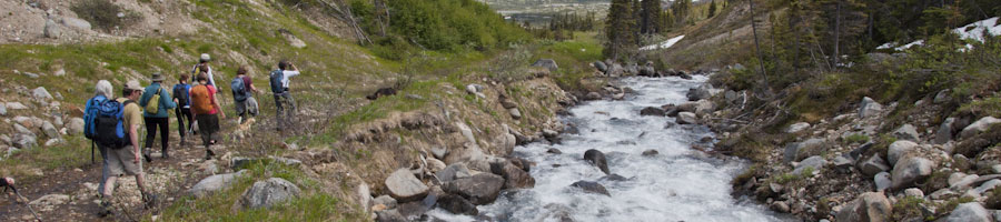
August 21, 2012. Lots of reorganizing on the site. First, I archived earlier material from this page (Blog archives I need to work more on the To do page to flesh out the advantages that certain steps could bring to walking: Spook Creek Trail, Yukon River Corridor Trail, Ball Diamond stairs,... August 16, 2012. Kids' activity rates on par with the Canadian average in the Star last night brought me to Canadian Fitness and Lifestyle Research Institute which has a link to Leisure Information Network. I'm looking forward to looking at walking and trails as a search. August 15, 2012. Walking is an interesting topic. Take Somehow we're walking more and walking less at the same time for instance. It partly poses the ideas of walking to get to a specific destination, or walking for the enjoyment of going for a walk. In our city, active transportation gets a lot of attention. My thought is that recreational walking should be more of a focus. A nicely paved trail alongside a road will have a hard time competing with a nice dirt track along a river or back in the woods. Active transportation for walkers has a tough battle outside of the downtown core. We're too spread out. There's few commercial services such as corner stores in most neighbourhoods. So getting to work and home again, or buying groceries, or going out for a coffee is not an easy walk for most people. If we want to help people walk, then focusing on recreation makes more sense. Are there good trails in every neighbourhood that access interesting destinations? Are special walks well signed, mapped and promoted? Are any neighbourhood associations Guide to city government to better our walking conditions? August 9, 2012. Back to mapping. The next draft of the Walking map for McIntyre Creek trails is posted here. Will these maps help to better walkers' experiences in Whitehorse? I hope so. Tonight's Whitehorse Star had 2 stories of interest to walking. The first, Park rowdiness has 'bloody-well got to stop', was the Lower Escarpment Trail and the partiers there, and the second 'What have we done to make people so upset?' was about people not liking changes being done to rehabilitate part of McIntyre Creek. Would more people out walking in these areas and caring about the land there make a difference? The Yukon News had a story Ta'an Kwach'an Council restores dump site about celebrating the tremendous clean-up Ta'an Kwach'an have pulled off over the past few years at the mouth of McIntyre Creek. This shows that if people care things can happen. This spot is a key location in a Yukon River Corridor Trail. July 10, 2012. Walking in the north can be a big thrill sometimes. Our places to hike can be absolutely spectacular. Being part of a hiking group can bring a sense of safety for hiking in some places. Above picture at Fraser was definitely in bear country. June 22, 2012. As to the Yukon River Corridor Trail: It's obvious that such a trail will cross over or past a number of pieces of KDFN land. The opening of the KDFN Cultural Center and its "Back to the River" slogan, fits very well in having a trail alongside the river. I've done another look at corridor map, essentially 4 larger views with a few notes of the draft corridor trail map. KDFN land is shaded purple. Note that I show the larger KDFN land pieces but often my accuracy is limited by whichever KDFN land maps I find in various publications. The corridor trail could be longer since past the city limits, it's only about 15 kilometres further to the Yukon River Bridge near Marsh Lake — almost entirely through KDFN land. June 17, 2012. I created the first draft of a map of a proposed Yukon River Corridor Trail. I was curious about the length of a trail ( ~45 km.) There is much already in place (~27km), and some exploration and decisions for the remaining (~17km). A couple of years ago, Wynne and I walked the coastal trail around the Isle of Man and this year we walked the trail around the Isle of Wight. So my walk with Nathan provoked me to wondering if as a city it was too late to have a city-long waterfront trail. I've started by marking some of the existing trails. Is it something we as a community would want? I wondered what the new Zoning By-law maps would show.. Some areas like the Marwell area need fast work if development isn't to shut the door on a trail like this. The Isle of Man's Coastal path started just like this, identifying existing pieces and then trying to join them. At times the trail goes inland, but slowly they are working with landowners for right of ways along the coastal edge of farms. It's a pretty neat project and was a great walk. 95 mile, 11 days, backpacks and B&Bs. See our slide show. As a follow-up, I walked the river trails from Takhinii Trailer Court out to the confluence of McIntyre Creek. There's phenemonomal views in places. A trail follows both on the upper escarpment as well as the lower escarpment. Both trails need help in spots. The lower trail brings you out in the area of the old dump. It's still got junk and tires and the odd car part, but is looking much cleaner than my last hike here. A simple trail route up the escarpment would be nice. A trail around the new subdivision would help new residents become active trail walkers. I wondered about Whistle Bend. What trails were there before Phase 1 development started, and which ones are left. Is a riverside trail still possible, or are we too late? I'm trying to find a development map that addresses a final vision of trails in the area. I've added a number of background planning maps to my google earth database, but need to connect with a current trail user for discussions and walks in this area. That brings me to McIntyre Creek. I really would like to get a better idea of the major trails in the creek area. Help! In our above-the-airport area, I've looked more carefully at the trail to the Rock Gardens, as well as asking the Zoning process to consider this trail's needs in their new zoning map. Likewise, the south side of Copper Ridge needs a Trail Corridor before development blocks us from trails in this area. As part creating our neighbourhood's part of Whitehorse's core trails, I hiked a couple of trails across the first wetland to get to the ski club trails. The city is looking at improving one of these trails by adding some swithbacks. This would be great as it's otherwise a steep up and down. Our above-the-airport trails and greenspaces group met with the City's trail consultant who told us we would shortly enter a task force process to determine plans for trails in the area. We pointed out that just because the City has only allocated a small budget for trails didn't make needs go away. A number of our loop trails that cross wetlands have become unusable. Since the new culvert was installed under Hamilton Blvd., changing water levels and increased motor vehicle traffic seems to be causing problems ion our trails, particularly in our wetlands. Our Hillcrest Community Association has been invited to be part of a process to develop a neighbourhood vision and plan for the Tank Farm as a stakeholder. A gated community has been mentioned. How that works with trail use will be interesting to see. July 12, 2012. When we walked on the Grey Mountain trails a couple of weeks ago, there were a few places where I wondered about safety. These were places where we were going up a blind hill and I wondered what move I'd get to make if a bike was suddenly to appear heading fast at me. It seems that some of the trails the city is working on with the mountain bike people need some warnings about this. Then I read When the bad guys ride bikes. So I went to look at a local bike site to see what was happening on trails from bike people's point of view and found Contagious Mountain Bike Club. After the two motorized vehicle task forces recently and the emphasis on education and codes of ethics as a way of resolving conflicts, I looked for a code of ethics on the site. All I found was their Adopt a trail page where they refer to the trails as "our trails." I'm pretty sure these are not officially "their" trails as certainly many predate mountain bike discovery. Hopefully it doesn't take a bad accident before this becomes a topic of discussion. July 10, 2012. Walking in the north can be a big thrill sometimes. Our places to hike can be absolutely spectacular. Being part of a hiking group can bring a sense of safety for hiking in some places. Above picture at Fraser was definitely in bear country. The Yukon's new Pathways to Wellness website explores many aspects of living healthily. Not only is hiking in a group safer at times, it's also good for our mental wellbeing and fun, as seen in the website's walking in groups! Celebrate Walking in Whitehorse! Whitehorse Walking Day — August 20, 2012Share the pleasure of walking, get active, learn something new, promote sustainable tourism and help preserve Whitehorse's unique trail system. Whitehorse has an incredible trail network that not only gets people active and from place to place but comes complete with stunning scenery and fascinating history. July 6,7 2012. My birthday link this week: This regional blog, Carolina Thread Trail, is about a trail network through a number of communities in Carolina. There are 15 counties and 2.3 million people, with 93 miles of The Thread open to the public — linking people, places, cities, towns and attractions.The blog has sections on health and environmental benefits, and a variety of resources on advocacy, funding and promotions of trails. One link What economic impact do trails have in our communities? looks at economic benefit from trails to communities and businesses. The business findings are particularly interesting for those who are interested in a downtown waterfront trail. Under "resources" is 4th Annual Trail Forum Presentations with excellent background presentations such as a 108-page PDF Natural surface trail maintenance — problem solving and repairing trail damage. There's also a 38-page pdf The trek before the trail,
engaging healthy living and maintaining advocate momentum which advises how to gain a voice in planning. Talking about Community support, one page is: Also under "resources" is maintenence and management with articles such as Tunnels on trails, a study of 78 tunnels on 36 trails in the United States,rails to trails (Interesting as we look at the barrier that the Alaska Highway makes between the above-the-airport neighbourhoods and downtown.) There's a link to Handbook for trail design, construction and maintenance and one on Conflicts on multiple-use trails: synthesis of the literature and state of the practice (Interesting as we try to control trail conflicts in Whitehorse). July 4, 2012. America Walks has the final report of National Walking Survey 2011 July 3, 2012. As I continue to look at the July 1st entry(below), here's some highlites: Resources and Library: Cool Trail Solutions This area is devoted to photos and graphics of SOLUTIONS to a wide array of trail-related problems. Our goal is to enhance our resources for trails planning, development, and management with visual ideas from across the country. Healthy Challenges: an editorial: "America's health and fitness crisis creates an opportunity to promote trails and greenways.A second challenge is to learn from the inactive people as well as from the active ones. We need to know what trails look like from the perspective of people who don't use them. We hear all the time from the trail runners, peak baggers, endurance riders, and hill climbers. But how do we help people take those first steps to healthy activity? How do we teach them about the delights and emotional benefits of being on a trail instead of a treadmill?" or, Resources and Library: Community Trails Systems: There are many benefits of trails and greenways that planners, funders, and the public need to know about: they make our communities more liveable; improve the economy through tourism and civic improvement; preserve and restore open space; and provide opportunities for physical activity to improve fitness and mental health. July 2, 2012. Look, Don't Touch, The problem with environmental education "THE BIG QUESTION IS: what's the most effective way to parent and educate children so that they will grow up to behave in environmentally responsible ways? Or, more specifically, what kinds of learning, or what kinds of experience, will most likely shape young adults who want to protect the environment, serve on conservation commissions, think about the implications of their consumer decisions, and minimize the environmental footprints of their personal lives and the organizations where they work? Interestingly, there's an emergent body of research that's starting to clarify the relationship between childhood experience and adult stewardship behavior. "First, a number of researchers surveyed environmentalists to determine if there were any similarities in their childhood experiences that might have led to their having strong ecological values or their choice of an environmental career. When Louise Chawla of the University of Colorado reviewed these studies, she found a striking pattern. Most environmentalists attributed their commitment to a combination of two sources, "many hours spent outdoors in a keenly remembered wild or semi-wild place in childhood or adolescence, and an adult who taught respect for nature." Involvement with organizations like Scouts or environmental clubs was cited by significantly fewer of the respondents. Chawla found that environmentalists talk about free play and exploration in nature, and family members who focused their attention on plants or animal behavior. They don't talk much about formal education and informal nature education. Only in late childhood and adolescence do summer camp, teachers, and environmental clubs start to show up as being contributors to the individual's environmental values and behaviors. It seems that allowing children to be "untutored savages" early on can lead to environmental knowledge in due time." As an explore off trail person, this article is interesting. I do note that I seldom see kids out in the woods playing. Partly this is because I tend to walk in the early afternoon. I've often looked at the city's offering of organized recreation and wondered why there seldom seemed to be crash-through-the-woods-type of programming. July 1, 2012. Here's my 3rd part of my birthday present. At first glance all I can say is WOW! American Trails, the world's largest online trails resource has a 'Resources and Library: Health & Fitness' page with lots of interesting resources related to trails and health, including a variety of studies talking about how trail use can impact health. In particular, a link to this study "Promoting physical activity in rural communities: walking trail access, use, and effects" which concluded "Walking trails may be beneficial in promoting physical activity among segments of the population at highest risk for inactivity, in particular women and persons in lower socioeconomic groups." June 26, 2012. From The Grave Health Risks of Unwalkable Communities : "The idea is to provide more choices, in how to get around and what to do outdoors, and especially, more healthy choices. You might still live in your current suburban house, if you want, but find that you can now walk to a small town center nearby that has a bus or streetcar stop, a little park, and a market. As a result you can get a quart of milk without burning up a quart of gasoline. Along the way, you might see a neighbor, exchange some news, or bring the kids for a nice walk. And you might not just be improving your life: you could be saving it." June 25, 2012. Today was finally compiling a response to Draft 2 of 2012 Zoning By-law rewrite process, deadline today of course. It's also accessible from the Planning page. In the process I also updated the above-the-airport and the downtown/Riverdale neighbourhood travel maps linked off the walks page June 24, 2012. Looking further at the Alberta Governments website and then at the City Of Edmonton's Walkable Edmonton website. Read about this on the walkability, sustainable design page. June 23, 2012. Here's the next try at creating a neighbourhood travel map. It's for the above-the-airport neighbourhoods. The red shading is PG, PR zoning (ie greenspace) and it has neighbourhood destinations. It doesn't have trails as destinations. Is it a walkable area? Certainly Hamilton Blvd. is a dominant barrier. June 22, 2012. A great summer so far since every day has had lots of sun! Here's part 2 of my birthday present: As to the Yukon River Corridor Trail: It's obvious that such a trail will cross over or past a number of pieces of KDFN land. The opening of the KDFN Cultural Center and its "Back to the River" slogan, fits very well in having a trail alongside the river. I've done another look at corridor map, essentially 4 larger views with a few notes of the draft corridor trail map. KDFN land is shaded purple. Note that I show the larger KDFN land pieces but often my accuracy is limited by whichever KDFN land maps I find in various publications. The corridor trail could be longer since past the city limits, it's only about 15 kilometres further to the Yukon River Bridge near Marsh Lake — almost entirely through KDFN land. June 17, 2012. I created the first draft of a map of a proposed Yukon River Corridor Trail. I was curious about the length of a trail ( ~45 km.) There is much already in place (~27km), and some exploration and decisions for the remaining (~17km). June 15, 2012. A great birthday present I received this year is 20 annotated resources, 1 a week. Here's the first: From strategy to action — case studies on physical activity and the built environment, by British Columbia Provincial Health Services Authority. This guide has a wide variety of case studies that look at the built environment and health. One great project is Sandne's, Norway's Children's trail program: "As part of the initiative, children 8-13 years old at all schools recorded on maps their informal play areas, paths and trails. In all, the children identified 1265 play areas, 550 short cuts, 130 reference areas for schools and 185 reference areas for nurseries. The information was transformed into digital form and made available through the municipal mapping program. Consideration of the Children's Trails report is a permanent routine in all physical planning." June 13, 2012. Reading Nearly $1.4 million in sport and recreation funding announced in the Whitehorse Star today, I was again struck by how the walking community has no voice. June 12, 2012. Walkability. As I look at Whistle Bend and how it will fit into a Yukon River Corridor Trail, I find myself reading many things: - The latest draft of the Zoning By-law: Map 6: Whistle Bend; I'm curious what people who currently use the trails in the area think. I'll post some map overlays showing the increasing drift from greenspace to residential. I'm interested in the conceptual trails on the greenspace map and whether they are just consultant's visioning or are the best trails for views. June 10, 2012. Added in some more Yukon River Corridor Trail. McIntyre Creee, up to, and partly around Whistle Bend. Stunningly spectacular views. June 7, 2012. Physical inactivity costs $6.8B a year to taxpayers "Between 2007 and 2009, only 15 per cent of adults were getting the recommended 150 minutes of weekly exercise. The country's youth were still more sedentary, with only nine per cent achieving the minimum amount of activity." Added in a few neighbourhood connector maps on the neighbourhoods page. Did some cleanup on the walks and resources pages. June 6, 2012. Metro Vancouver parks under 'significant stress' Report warns funding must be doubled to improve parks, provide space for growing population. Whitehorse's tiny trails budget is a big problem. Trails need a fresh look under city planning. May 29, 2012. A full day attending the Visioning meeting for the Tank Farm development. A lot happening and big changes are very possible. We've been trying to keep both walkability and residential as two prime objectives and so far it looks very good. Next steps are to ensure that the walkability need of crossing the highway at the tank farm stays in the picture. Likewise, a large segment could easily become highway commercial, which would be a waste of very strategically placed residential land. The result of the workshop will be at a Public Open House: tomorrow, Wednesday, May 30th; CANADA GAMES Centre, Boardroom; 5:00pm – 7:30pm. It's an interesting process and there's a determined desire to clean the site and to develop it in a manner we can be happy with. Let's get the problems and objections and the OKs out on the table at the beginning! This will work very well in that as a result of this process, Spook Creek will be cleaner faster and its use as a connector trail/parkette is even more reasonable. May 28, 2012. Trails, trails, and sharing trails. As I search internet for aspects of trails I'm struck by the growth of mountain biking here.From one blog "The city has dumped loads of money into the trail network and it is growing with every new season." I started a section called Safety and maintainability on the To do page. I'm seeing that the ' To do' page and the 'Planning' page have much in common and I'll have to address this.
From today's Globe and Mail Why is walking in the woods so good for you? "...believe that going for a walk in the park gives voluntary attention a break, since your mind has a chance to wander aimlessly and be engaged – involuntarily but gently – by your surroundings." NOTE: In our above-the-airport area there's a workshop happening to develop a preliminary concept plan for the Tank Farm." The purpose of this project is to clean up the former Tank Farm property and create a neighbourhood plan to guide redevelopment of the site in a way that meets the needs and aspirations of the community and stakeholders". On Wednesday, May 30, 5:00pm – 7:30pm, there'll be Public Open House at Mt McIntyre Rec Centre, Boardroom on the workshop result. May 26, 2010. I've been looking more at Whistle Bend trails in light of the new draft Zoning By-law. I would like to walk there with someone who know more about the trails there. I'll try to post some screen snapshots of the area. May 25, 2012. A creative life is a healthy life. Following your passion, being creative, the link creativity and better mental and physical health. In short, it's OK for me to pursue these walkability ideas! Today's walk. May 24, 2012. I'm slowly working on my walking website and though I'd summarize what I've been doing since our return from travels. I have done some cleanup of coding and organization so hopefully the site is easier to use and to update. I need to resolve the blog aspect of the website. This is still not clear to me so I'll just post updates for now. I've been discussing the proposed staircase at Hanson/Hawkins with people I meet. It seems that while useful, a better option would be building stairs behind the ball diamonds at Yukon Energy. This would open up many trail possibilities and encourage much broader walking participation among downtown and Riverdale walkers. I hear from the City that they only hear me say this. If people called City Council or Parks and Recreation, maybe they'd look at this. I'll make a page on this soon. I walked with Nathan Miller from the Downtown Residents Association. We looked at how to connect the lower escarpment trails to the Yukon River Trail. The escarpment part from the Black Street stairs to the intersection at 2nd and 4th needs some work. Creating a Spook Creek Trail looks like an interesting community-building opportunity as with residents working with the business community It could be a real win-win situation. We also looked at the Waterfront Trail as it petered out in the Marwell area, and wondered what it would take to extend this trail through the Marwell area. I'd been looking at how one gets down from the College area to the Waterfront Trail. Seems for now that walking along Mountainview Drive and then along Copper Road is how one must do it? Uggg! This got me to wondering whether a trail alongside the Yukon River in the city was feasible. It seems there are some obstacles, but it's an idea worth looking at. As a community we seem to be pretty negligent in having a vision for our trails. A couple of years ago, Wynne and I walked the coastal trail around the Isle of Man and this year we walked the trail around the Isle of Wight. So my walk with Nathan provoked me to wondering if as a city it was too late to have a city-long waterfront trail. I've started by marking some of the existing trails. Is it something we as a community would want? I wondered what the new Zoning By-law maps would show.. Some areas like the Marwell area need fast work if development isn't to shut the door on a trail like this. The Isle of Man's Coastal path started just like this, identifying existing pieces and then trying to join them. At times the trail goes inland, but slowly they are working with landowners for right of ways along the coastal edge of farms. It's a pretty neat project and was a great walk. 95 mile, 11 days, backpacks and B&Bs. See our slide show. As a follow-up, I walked the river trails from Takhinii Trailer Court out to the confluence of McIntyre Creek. There's phenemonomal views in places. A trail follows both on the upper escarpment as well as the lower escarpment. Both trails need help in spots. The lower trail brings you out in the area of the old dump. It's still got junk and tires and the odd car part, but is looking much cleaner than my last hike here. A simple trail route up the escarpment would be nice. A trail around the new subdivision would help new residents become active trail walkers. I wondered about Whistle Bend. What trails were there before Phase 1 development started, and which ones are left. Is a riverside trail still possible, or are we too late? I'm trying to find a development map that addresses a final vision of trails in the area. I've added a number of background planning maps to my google earth database, but need to connect with a current trail user for discussions and walks in this area. That brings me to McIntyre Creek. I really would like to get a better idea of the major trails in the creek area. Help! In our above-the-airport area, I've looked more carefully at the trail to the Rock Gardens, as well as asking the Zoning process to consider this trail's needs in their new zoning map. Likewise, the south side of Copper Ridge needs a Trail Corridor before development blocks us from trails in this area. As part creating our neighbourhood's part of Whitehorse's core trails, I hiked a couple of trails across the first wetland to get to the ski club trails. The city is looking at improving one of these trails by adding some swithbacks. This would be great as it's otherwise a steep up and down. Our above-the-airport trails and greenspaces group met with the City's trail consultant who told us we would shortly enter a task force process to determine plans for trails in the area. We pointed out that just because the City has only allocated a small budget for trails didn't make needs go away. A number of our loop trails that cross wetlands have become unusable. Since the new culvert was installed under Hamilton Blvd., changing water levels and increased motor vehicle traffic seems to be causing problems ion our trails, particularly in our wetlands. Our Hillcrest Community Association has been invited to be part of a process to develop a neighbourhood vision and plan for the Tank Farm as a stakeholder. A gated community has been mentioned. How that works with trail use will be interesting to see. Peter |